


About Ionospheric Scintillation
- What is Ionospheric Scintillation?
- When and where does Ionospheric Scintillation occur?
- What is the Impact of Ionospheric Scintillation?
- Measuring Ionospheric Scintillation
- Ionospheric Scintillation Monitor (ISM)
What is Ionospheric Scintillation?
Ionospheric scintillation is a rapid fluctuation of radio-frequency signal phase and/or amplitude, generated as a signal passes through the ionosphere. Scintillation occurs when a radio frequency signal in the form of a plane wave traverses a region of small scale irregularities in electron density. The irregularities cause small-scale fluctuations in refractive index and subsequent differential diffraction (scattering) of the plane wave producing phase variations along the phase front of the signal. As the signal propagation continues after passing through the region of irregularities, phase and amplitude scintillation develops through interference of multiple scattered signals.

When and where does Ionospheric Scintillation occur?
Ionospheric scintillation is a well-known phenomenon that has been studied extensively in the past yet it remains a difficult phenomenon to predict or model on a large scale. Scintillation is caused by small-scale fluctuations in the refractive index of the ionospheric medium which in turn are the result of inhomogeneities. Inhomogeneities in the ionospheric medium are produced by a wide range of phenomena (eg plasma bubbles), and those responsible for scintillation occur predominantly in the F-layer of the ionosphere at altitudes between 200 and 1000km. The primary disturbance region, however, is typically in the F-region between 250 and 400km. E-layer irregularities such as sporadic-E and auroral E can also produce scintillation but their effect on L-band GPS signals is minimal.
Ionospheric scintillation is primarily an equatorial and high-latitude ionospheric phenomenon, although it can (and does) occur at lower intensity at all latitudes.
In terms of geographic (geomagnetic) distribution, ionospheric scintillation generally peaks in the sub-equatorial anomaly regions, located on average ~15° either side of the geomagnetic equator, as can be seen in Figure 1, below.
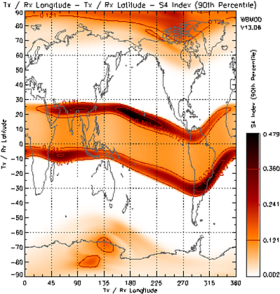
Figure 1: S4 Scintillation index at GPS L1 (1575.42MHz) assuming constant local time (2300) at all longitudes.
The figure shows "WBMOD" model predictions of the 90th percentile S4 index at 2300 Local Time (everywhere) at the S.Hem autumnal equinox (DOY 091) for GPS L1 (1575.42MHz), low magnetic activity (Kp=10) and high solar activity (SSN=150). Apart from the two strong scintillation bands following ~15° geomagnetic latitude contours, also obvious is the enhanced scintillation between the two bands of maxima and in the polar regions. The mid- latitude regions are relatively free of scintillation, especially at GHz frequencies, however at lower frequencies, closer to 100MHz there can at times be significant scintillation activity.
In terms of diurnal distribution, equatorial ionospheric scintillation generally peaks several hours after dusk, as can be seen in Figure 2, below.
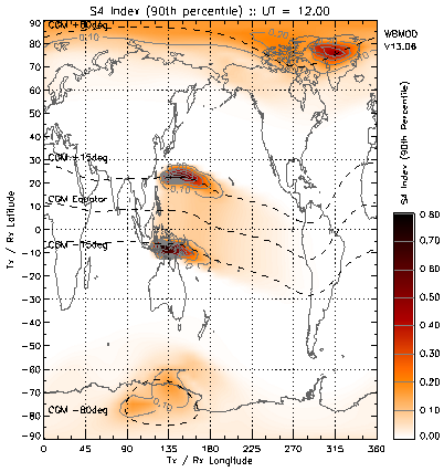
Figure 2: S4 Scintillation index at GPS L1 (1575.42MHz) assuming constant Universal time (1200). The dashed lines represent lines of constant geomagnetic latitude (as marked).
The figure shows "WBMOD" model predictions under the same conditions as Figure 1 but for 1200UT, rather than at constant local time. The choice of 1200UT during equinox means the left and right hand borders of the plot are at midday local time, the vertical centre line of the plot (longitude 180°) corresponds to local midnight, and dusk is at longitude 90°. Each division on the X axis (15°) corresponds to 1 hour. Again, two strong scintillation bands can be seen roughly corresponding to ±15° geomagnetic latitude (as indicated by the dashed lines). The equatorial scintillation is present at decreasing intensity levels throughout most of the nightside. The scintillation peak in the equatorial regions occurs between 2100 and 2200 local time.
In general, GPS receivers located at mid-latitude sites in Australia (-40° < latitude < -20°) will not be significantly affected by ionospheric scintillation. GPS receivers located at latitudes north of -20° in Australia may experience some degree of ionospheric scintillation, primarily when tracking satellites at low elevation angles to the north, and during active geomagnetic conditions. Locations as far north as Darwin and the Cape York Peninsula are likely to experience ionospheric scintillation more regularly on satellites tracking to the north of the station since the Line Of Sight (LOS) to these satellites will generally pass through the equatorial anomaly regions. GPS receivers located at latitudes southwards of -40° will commonly see ionospheric scintillation activity associated with geomagnetic storm activity, on satellites tracking to the south of the receiver, with the most significant scintillation occurring under the auroral zones.
What is the Impact of Ionospheric Scintillation?
Ionospheric scintillation affects trans-ionospheric radio signals up to a few GHz in frequency and as such can have detrimental impacts on satellite-based communication and navigation systems (such as GPS-based systems) and also on scientific instruments requiring observations of trans-ionospheric radio signals (eg radio-astronomy).
Amplitude scintillation directly affects the signal to noise ratio (C/No) of signals in a GPS receiver, as well as the noise levels in code and phase measurements. Amplitude scintillation can be sufficiently severe that the received GPS signal intensity from a given satellite drops below the receivers tracking threshold, causing loss of lock on that satellite, and hence the need to re-acquire the GPS signal(s). This results in reduced accuracy navigation solutions, data loss and cycle slips. The nominal C/No for the L1 signal is about 45dB-Hz, and tracking may be lost when the signal drops below ~25dB-Hz, dependent on the receiver-specific tracking loop.
Since the signal power on the GPS L2 frequency is significantly less than that of L1 (~6dB lower), and civil dual frequency receivers use non-optimal codeless or semicodeless techniques for tracking L2 which results in lower C/No values, ionospheric scintillation is much more likely to impact the GPS L2 signal.
Phase scintillation, if sufficiently severe, may stress phase-lock loops in GPS receivers resulting in a loss of phase lock. Phase scintillation also has a significant impact on phase-sensitive systems such as space-based radars (eg image defocussing in synthetic aperture radars (van de Kamp et al, 2007)) and some ground-based radio-astronomy facilities (eg SKA/LOFAR prototypes (van Bemmel et al, 2007)).
Measuring Ionospheric Scintillation
There are numerous measures of ionospheric scintillation. Perhaps the most common of these is the amplitude scintillation index S4, and the phase scintillation index Prms. Ionospheric scintillation models produce statistical measures of the specified scintillation index. To produce maps it is necessary to either specify thresholds of this index or to specify a percentage of time an index is exceeded.
Amplitude scintillation - S4
Amplitude scintillation is quantified by the S4 parameter which is defined as the square-root of the normalised variance of signal intensity over a given interval of time:

where I is the signal intensity.
S4 is a dimensionless number with a theoretical upper limit of 1.0, commonly estimated over an interval
of 60 seconds.
There are two defined regimes of amplitude scintillation: weak and strong, which roughly correspond
to the type of scattering associated with each. Strong scintillation is generally considered to occur when
S4 is greater than ~0.6 and is associated with strong scattering of the signal in the ionosphere. Below this
is weak scintillation. An S4 level below 0.3 is unlikely to have a significant impact on GPS.
Phase scintillation - Φrms
Phase scintillation is quantified by the Prms (or Φrms) index which is defined as the standard deviation of the signal phase over a given time interval. This index is measured either in radians or degrees. A Prms greater than ~ 1° is considered to be strong scintillation. At mid-latitudes, Prms rarely exceeds 1° for more than 1% of the time.
Other scintillation parameters
CkL - Log of the height-integrated irregularity strength (calculated on L.O.S paths from the ground to an overhead satellite). A measure of the total "power" in the electron-density irregularities along a vertical path passing through the entire ionosphere.
Scintillation Intensity (SI) index - Derived from scintillation data recorded on paper chart. Scintillation Intensity index (SI) is defined as:

where Pmax is the power of the 3rd peak down from the maximum excursion shown during a scintillation occurrence, and Pmin is the power of the 3rd peak up from the minimum excursion. These values can be readily and rapidly scaled from a calibrated chart. The SI index is expressed in decibels (dB). An SI value of 15dB corresponds to an S4 of about 0.6.
Ionospheric Scintillation Monitor (ISM)
An Ionospheric Scintillation Monitor (ISM) is a single- or dual-frequency GPS receiver specifically designed to monitor ionospheric scintillation levels in real time. The ISM has wide-bandwidth tracking loops to maintain lock longer during intervals of strong ionospheric scintillation, and samples at a rate of 50 Hz to calculate the scintillation statistics S4 and Prms. The wide-bandwidth tracking improves tracking through strong scintillation however loss of lock on single or multiple satellites can still occur during extreme events, requiring re-acquisition of the GPS signal(s).
SWS Radio and Space Services uses GPS Silicon Valley's GPS Ionospheric Scintillation and TEC Monitor (GISTM) system Model GSV4004B to monitor Ionospheric Scintillation in real time. The GSV4004B consists of an L1/L2 GPS Antenna, a dual-frequency GPS receiver (NovAtel's Euro-3M with modified firmware), and a low phase noise oven-controlled crystal oscillator (OCXO), housed in NovAtel's EuroPak-3M enclosure. The OCXO is required for monitoring phase scintillation.
The primary purpose of the ISM system is to collect ionospheric scintillation statistics (S4 and Prms) for all visible GPS satellites (up to eleven satellites) and store these (ISMR) binary data logs on the receiver controller hard disk for post processing. The ISM control software can be programmed to collect the ISMR data logs that are generated every 1 minute. Alternatively, raw phase and amplitude data at 0.02 second temporal resolution (50Hz) and code/carrier divergence at 1s (1Hz) can be recorded from the ISM. These data can be used to reconstruct the statistical scintillation indices, such as S4 recorded in the ISMR data log, from raw data. This allows the user to modify the parameters used in the derivation of scintillation indices, such as de-trending and filter cut-off parameters.
References
van de Kamp, M., P. S. Cannon, and M. Terkildsen (2009), Effect of the ionosphere on defocusing of space-based radars, Radio Sci., 44, RS1003, doi:10.1029/2007RS003808.
van Bemmel, I. M. and H. Röttgering (2007), Ionospheric limitations for SKA and LOFAR, Proceedings of Science, PoS(MRU)012, https://pos.sissa.it/052/012/pdf